Area:
total: 43,094 sq km
land: 42,394 sq km
water: 700 sq km
note: includes the island of Bornholm in the Baltic Sea
and the rest of metropolitan
Denmark, but excludes the
Faroe Islands and Greenland
|
Land use:
arable land: 60%
permanent crops: 0%
permanent pastures: 5%
forests and woodland: 10%
other: 25% (1993 est.) |
Population:
5,336,394 (July 2000 est.) |
1. Land Administration
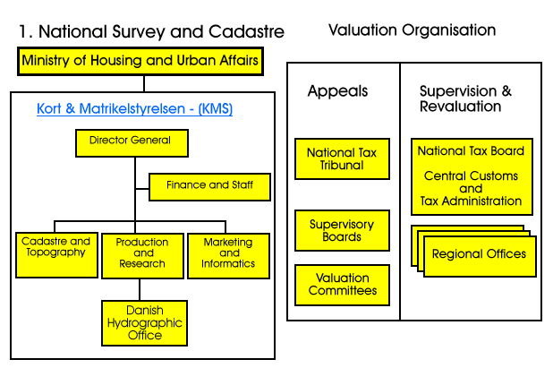
The Land Registry
2. General Remarks
Since long ago the so called BBR (Building and Dwelling Register) is
established. It is nationwide. Furthermore there is a computer-based Real
Property Register and a Digital Cadastral Index. At present a computerized
Land Register is being implemented. Within the tax administration there is
also a considerable amount of land-related information, and Denmark has come
quite far when it comes to computer-based assessment (CAMA). This information
is to a large extent more person- than property-related.
From a privacy perspective the Danish Land Register is of greatest interest.
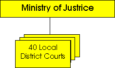
Land registration takes place at the local courts and the Land Registration
Unit of the Ministry of Justice has the responsibility for the Land Registration
System. This register contains in principle the same information as the Swedish.
Credit institutions, municipalities, solicitors, real estate agents and others
with a legal interest in land registration have the possibility to have direct
access to the computerized Land Register. The number of direct access users
amounts to around 16,000. There is no possibility of selection and processing
and there are no plans to develop such functions. However certain selection
possibilities exist in the tax systems.
Certain limitations concerning the usage exists in legislation that
surrounds these registers.
In Denmark the minister of Research and IT presented an IT White paper
to the parliament, discussing providing better services and creating efficiency.
Aim is a better access to government information as well.
KMS`s (Kort & Matrikelstyrelsen)
Tasks
KMS?s tasks incl1ude geodetic surveying and topographic mapping of Denmark,
the Faroe Islands and Greenland and charting of the surrounding waters. This
includes the establishment and maintenance of national geographic databases
and actual production of national topographic maps and nautical charts.
KMS is responsible for the cadastral system and the authorization of
licenses surveyors. This includes the formulation and maintenance of rules
applying to the cadastral system, approval and registration of cadastral system,
approval and registration of cadastral changes outside the municipalities
of Copenhagen and Frederiksberg and cadastral survey assignments and certain
technical survey assignments in South Jutland.
KMS also performs tasks related to the real property data registers,
the parcel register, the cadastral maps and the Building and Dwelling Register.
Being a government research institute for mapping and geodata, including
geodesy and seismology, KMS carries out research and development tasks within
the entire area of responsibility.
3. Projects
The establishment of digital cadastral maps covering the total country
was achieved by the end of 1997. The process commenced with a pilot-project
carried through from 1985 to 89, and the continued computerization of the
maps then took place during the first eight years of the 1990.
The aim of this computerization of the cadastral maps was to establish
a digital cadastral information system which would be tailored for efficient
interaction with other spatial information systems; and (ii) provide an effective
and secure process of land registration and land transfer.
This aim is not easy to achieve. This is due to the fact that the cadastral
map has a special status as a ?legal map? which - for many reasons - may not
be consistent with the topographic map.
The demand for an absolute accuracy is rather small in this ?legal map?.
The cadastral process is focused on the relative accuracy between the parcel
boundaries. However, the users (local land use authorities, utilities etc.)
will see the absolute accuracy as necessary in order to be able to combine
the legal property features in the cadastral map with the spatial features
in the large scale topographic maps.
The tension between the relative and absolute accuracy of the boundaries
may therefore be seen as the main problem of establishing and running the
digital cadastral map. The relative accuracy must be sustained for legal reasons
while an absolute accuracy should be obtained for the reasons of multipurpose
use.
This is why the procedures for updating the digital cadastral map will
be opposite to the procedure for updating the analogue map. In the analogue
map new boundaries were adjusted graphically to the position of existing mapped
boundaries. In the digital cadastral map any new cadastral measurement will
be used for adjusting the position of the existing boundaries. This will
establish a process of continual improvement of the accuracy of the map -
a dynamic system.
It is however recognized that some problems may arise in practice when
a decision has to be made on the area to be included in the adjustment. A
general understanding of these problems related to the process of establishing
and maintaining the digital cadastral map are essential for all users. In
other words, the success of the digital cadastral map will depend on the degree
of educated use of the map.
|
Project |
Begin |
End |
Purpose/Sector |
Assitance/Cooperation |
Ministry |
Organization |
Contact |
covered
area |
General remarks: Maps and registers are in nationwide digital form by the
end of 1997.
In the years to come efforts will be done to implement and improve
the use of the digital cadastre. |
|
Improve the subdivision
proces due to the digital cadastre |
1997 |
2000 |
Improving |
KMS, Chart.surv.ass., Municipalities ass. |
Housing
and Building |
KMS |
KMS |
national |