Area:
total: 337,030 sq km
land: 305,470 sq km
water: 31,560 sq km
|
Land use:
arable land: 8%
permanent crops: 0%
permanent pastures: 0%
forests and woodland: 76%
other: 16% (1993 est.)
|
Population:
5,167,486 (July 2000 est |
Partner involved in LA
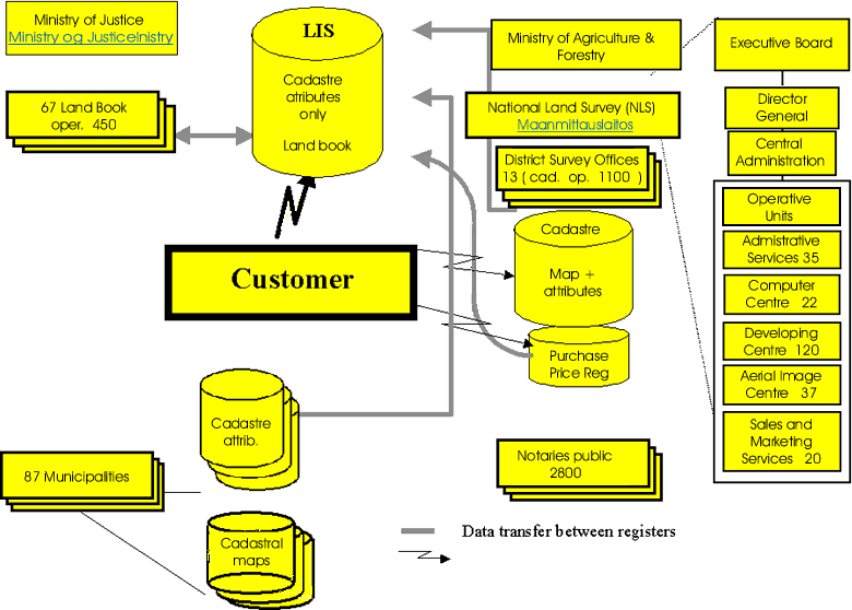
1. General remarks
Local courts are
responsible for confirming titles and mortgages in all of Finland. Responsibility
for cadaster is divided between the National Land Survey and municipalities.
Municipalities are responsible for their city planned areas, about 1.5 %
of total area, and the National Land Survey is responsible for the rest.
Conveyance of an sale is confirmed by a
notary public. The information
about sales are transferred by notaries to the
National Land Survey (NLS)
which records them into the
Purchase Price Register.
According to this information conveyances are transferred into the
Cadastre and the
Land Book. Whether it
is question about the conveyance of a whole property or part of it the purchaser
is obliged to apply for a title. After confirmation of the title parcelling
is activated automatically if the conveyance is removed land.
Both the NLS and municipalities have their own cadastral registers.
The data is transferred into a national Land Information System (LIS). The
LIS comprises of the Cadastre and the Land Book. The Cadastre of the LIS does
not contain map data so far. Registers for titles and mortgages, i.e. the
Land Book has no parallel system but run as a part of the national LIS. Digital
cadastral index map recorded in NLS` and municipalities` registers covers
now almost the whole country.
National Land Survey (NLS):
Improving the data quality of the cadastral register has been one of the
key goals of the NLS in recent years. The registration of common areas and
puplic roads is scheduled for completion by the end of 2000. The ownership
surveys of common water areas will be completed as scheduled in 2002.
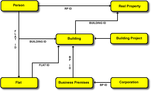
In Finland there are defined so called national registers. They are
registers for persons, buildings, flats, corporations and the LIS (Land Information
System). The relations between these registers are as follows:
http://www.nls.fi/
2. Projects
2.1 JAKO
In April 1998 the National Land Survey
(NLS) introduced the new cadastral system called
JAKO. The system manages in one database
all of the cadastral information: cadastral index map, survey map, background
maps, attribute and administrative data of cadastral units and surveys.
The final system takes care all of data processing in a survey. The system
does not yet support the most complex surveys as land consolidation and
expropriation surveys. The work is going on in order to manage also these
surveys in the near future. The system also supports information services.
More information can be obtained from Juha Tuomaala, Mikko Uimonen 1998:
Introduction of Finland`s New Object-oriented Cadastral Information System
(JAKO), XXI FIG Congress, Brighton, UK
http://www.nls.fi/jako/norm/taso2_eng.html
2.2 Spatial Consistency between Cadastral
and Topographic Data
Topographic data updating and surveys
are separate procedures. Although position determinations are improving
there always will be a difference between different measurements. When property
boundaries and topographic data are depicted at the same time, discrepancies
can be misleading.
The solution to the problem is that when new data is collected, is
it cadastral or topographical in nature, it or other type objects are corrected
according to the best position determination. This requires that this can
happen easy enough. This is achieved by using the same GIS tool in survey
and topographic mapping application. The system can update both databases.
Systems for topographic data update are in development. It will be realised
using the same GIS tool as the JAKO system. The new topographic applications
will be implemented in 1999 - 2000.
2.3 Renewal of the National LIS
The NLS has collected digital cadastral
index map for over 13 years. The job will be completed in 1999. The same
activity has happened in towns. In fact there are digital index map but it
is distributed. There is going on a project which plans and implements a
new national LIS which includes also the cadastral index map. Also some other
data as addresses and building identifications will be added to the register
content. The cadastral part will be based on the JAKO application which runs
on a UNIX platform. The existing Land Book will run still the next years
on an IBM/MVS/IDMS platform and the two systems communicate with an application
programming interface. The new system will be implemented in 2000. The Land
Book system running on the IBM mainframe will be renewed later.
The next step is to improve data management on land use rights and
restrictions on the national LIS. That data is so far given briefly as an
attribute data for every property. The improvement includes the spatial
description of the right and restriction objects and comprehensive attribute
data of these objects. The decision of the expansion of the LIS with the
data of land use and land use restrictions was made on a political level.
The planning and developing timetables are open so far.