Research
| New projects coming up soon | |||
| Energibyen Frederikshavn (2008- 2010) | |||
| InfraWorld (2008 - 2011) | |||
| My time in VR Media Lab (2000 - 2007) | |||
| Listed below you will find some major projects I have been involved in during my period at Aalborg University. During my time as a director of the VR Media Lab I have also been involved in a huge number of small and medium-sized projects where VR and 3D visualization has been the main focus. These projects have primarily been carried out together with the staff at VR Media Lab and private companies. Further these projects had the main purpose to try VR as new technology or media in a wide range of usage. Take a brief look here: VR Media Lab / projects |  |
||
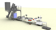
| Stålcentrum - RTC (2006 - 2008) | |||
| Visualisering som kommunikationsværktøj mellem kunde og leverandør | |||
| Projektet er finansieret af Videnskabsministeriet og bliver ledet af Teknologisk Institut i Kolding. Delprojektet som jeg deltager i fokuserer på visualisering af produktionsudstyr til fødevareindustrien, idet vi benytter både Cave'n og Panoramaet til at visualisere de dele, der indgår i produktionen. Vi bruger visualiseringen som led i kommunikationen mellem udstyrsleverandøren og fødevareproducenten. Herudover tager vi de første skridt til at optimere indretningen af arbejdspladsen, hvor denne er meget belastende for kroppen. Denne del er forarbejdet til en ansøgning i Højteknologifonden i 2007. |
Cabinplant model |
||
| IT in the Building Industry (2004 - 2007) | |||
VR Media Lab is part of a Consortium which contains of the major consulting engineering company Rambøll in Copenhagen as the lead contractor, Arkitema representing architects and coming from Århus and finally NCC representing the interests of the entrepreneurs. The consortium has the assignment to describe the demands of digital data within the building industry in a way that project data can be used all the way from the architectural competition over the consulting engineering part to the entrepreneur. The data should be able to handle 3d information and be identified as objects without being connected to any propriety software package. The project is financed by 2/3 from the danish "Erhvervs- og Boligstyrelsen". Further information can be obtained from the following link: Det digitale byggeri |
 |
||
| 3D GeoInformation (2001 - 2006) | |||
At the moment most of my research time goes to the 3d GeoInformation knowledge centre. This project was initiated in the late nine-tees and the application was granted in 2001.
The goal is to build a landscape model with all its features like buildings, vegetation etc. or at least as many features as possible. We want to be able to represent those features as objects in a database where it is possible to retrieve them again in real time. Together with the geometry of the objects it is possible to retrieve information which are connected to the features. The feature can be pointed at and selected in a 3d view on a display system. The system developed for that purpose goes under the name of GRIFINOR. GRIFINOR is a open source platform. Even if the funding has stopped now the knowledge centre continuous. Please go to the web page for GRIFINOR for further information.
|
|
||
| Earlier Work | |||
| 3D Visualization for Decision-Making (2002 - 2005) | |||
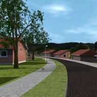
| In connection with the new "House of Music" in Aalborg the VR Media Lab has been involved in the decision-making process. All incoming projects have been visualized and presented in the Panorama following a well defined schema for the presentation. These visualizations where supposed to give an idea of the shape and volume of the different projects placed in the town model of Aalborg. After this process three projects where chosen for further negotiations and visualization work. So all three projects where modelled with the interior and again presented to the jury. Finally the winner was found. | 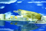 |
||
| Virtual
Reality In Planning (1998 - 2002) Creating 3D-Models for the Purpose of Planning |
|||
Why can our children move around in artificial Worlds playing the conqueror of the world, driving hazardously through virtual cities or killing outrageous monsters in a castle without getting even a scratch? The market of computer-games is huge and the people behind have developed smooth techniques making it possible to move around in virtual environments with very high refresh-rates between the computer-generated pictures. In the field of urban and regional planning or civil engineering 3D-modelling and animations have been produced in big numbers through the years. But it is very expensive and time-consuming building a good computer-model. Moving to virtual reality makes it even harder to use these techniques. This project faces the problems of building a good 3D-model, gives some ideas of how it can be done much easier and present a piece of software where these ideas have been implemented. This work shows that it is possible with very little 3D-modelling knowledge to use virtual reality as a tool in a planning process. |
 |
||
| Road-Pricing (1998 - 2001) | |||
At DTU in Copenhagen a big road-pricing project started early 1998. The project had the goal to develop a road pricing system different from those used world wide where you pay at a toll-ring at the outskirts to the inner city or simply for using a highway. The road-pricing system in this project calculates a price for every meter you drive on a specific road, which is divided into several price classes. I.e. driving on a highway in an open area is very much cheaper then driving in the inner city on a local road. This pricing system has the ability to control traffic around the city much more precise and hopefully convince as many as possible to use public transport instead of using private cars from and to work in the cities, or at least getting the motorist using major ways instead of the ways in the inner cities. At Aalborg University a prototype has been developed during spring 1999, which basics is a portable PC with a GPS attached giving the co-ordinates in the GIS system which is the heart of the system. In the GIS system the calculations will be done while the GPS is the positioning system which can be exchanged with another technology anytime. The prototype area is the city of Aalborg. The System was then: Toshiba Satellite Pro 490XCDT (PII 266, 160Ram), Trimble GPS NAV-GUIDE+, ArcView 3.1 and Tracker Analyst for ArcView. (About 4000$ all together). The prototype has been developed by Jesper Kruse during spring 1999, who wrote his master about this prototype to become a chartered surveyor. His diploma work can be downloaded at road-pricing.pdf (2,6Mb, only in Danish). This project
has been going on since then. New dedicated boxes with cpu and gps
included have been developed and other functionality like speed
control has been implemented. For more information look here: TRG |
 |
||
| The Staging of Virtual 3D-spaces (1997 - 2000) | |||
| Representation and building of Virtual Space | |||
Together with Lars Bodum from the GIM research group I have been working on a research project called "Representation and building of Virtual Space". The project was part of a large research effort within the area of multimedia in Denmark funded by the Danish National Research Council. The title of the framework in which this research project was a part, is "The Staging of Virtual 3D-spaces" and it dealt with all kinds of aspects regarding the nature and usage of interactive multimedia; which in general terms means the semiotic of interactive multimedia systems. Our part of the research project ran under the GIM research group, Aalborg University in Denmark. The purpose of the project was to define a universal common language for 3D interactive multimedia systems. The next space that the human race will inhabit will not be the Moon or Mars. It will be cyberspace. It is therefore highly relevant to start the process of planning how we want this space to be like and how we want to be able to interact with this domain. Many smaller settlements have already popped up around the Internet and other networked communities and more cyber-societies are coming as fast as technology is emerging. We need more knowledge about how it is possible to make representations of these virtual environments so that it will be possible for people in general to understand and interact with these virtual worlds. Although the physical laws of our real world are not directly applicable to these artificial worlds, we must remember that our perception of space (real or virtual) is dependent on our interpretations of the objects that are present within the space in question. In other words: If people in general do not understand the natural language of the space they are interacting within, they do not have a chance to communicate properly with either co-inhabitants, avatars or other intelligent objects in cyberspace. The purpose of the research presented in this work was to build an operational model for the simulation of spaces within a virtual world, and to reach this goal it becomes necessary to built prototypes of the system where different scenarios can be tested. The knowledge about these virtual spaces can only be built upon experience from the use of them in real life situations. The initial metaphor that are used in the project are taken from the world of the theatre. Using this terminology it becomes easy to understand the meaning and purpose of the different elements in the project. Like in the theatre there are authors, manuscript-writers, scenographers, actors, audience etc. in the virtual worlds that will be created. This specific project will concentrate on generating and building of the scenes and the wings. But contrary to the real theatre where you have to buy your tickets for a specific event and where you have to be in the theatre to follow a certain play, the acting on the scene in the virtual world will be depending on reactions from users or avatars that are in different places at different times. In respect to this fact it becomes necessary to think differently and develop new representations of the space in question. Using a framework where time and place are dependent variables, it is possible to describe the characteristics of some of the virtual worlds in action. By analysing these worlds we will build up an empirical knowledge about this phenomenon and try to define some of the needs of a virtual world prototype in respect to this project. Another very important aspect of the discussion is the different contexts that these virtual worlds should fit into. This work outlines the possible subjects that could be interesting for an early prototype.To understand how virtual worlds can be built, we think it is very important to know something about how models of the real world works and how we describe space in general. The spatial element and the knowledge about geographic information technology is usefully, also when we talk about virtual spaces. The outcome of the overall project is presented in a series of four books "Virtual Inhabited 3D Worlds" published by Springer Verlag. |
 |
||
| Raster-GIS (1996 - 1997) | |||
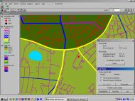
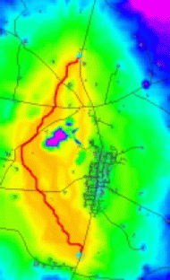
The use of GIS is primarily restricted to vector-based maps and information stored on well defined objects like houses, roads and other fields. GIS is first of all used as a database by many different public authorities to get a better general overview over the tons of data sampled through the years with computers in use. GIS is a lot more. So GIS is used for analysing and presenting great amount of data. Raster-GIS has not been used that much yet for this purpose because it is not immediately suitable. But it is an excellent tool for analysing pictures and very large amount of data. The problem is to produce the right picture. Raster-GIS is in my project used for the purpose of route-planning. In connection with a new road around a minor city different types of thematic maps (base map, Corrine land cover, forest, restricted areas and more) are converted from vector to raster. These maps are then classified to give a relation between them, compared and weighted by using map-algebra functionality. It is thereby possible to take a lot of different interests in account and weight them due to the importance of the theme. The GIS-system calculates a corridor for the cheapest path from the start point to the endpoint around the city, i.e. through less areas of interest. The project has been carried out together with Anders Forsberg (SIGIT, Sweden) |
 |
||
CAD
Design (1991 - 1995) | |||
One of my major interests is digital design and especially CAD-design used in road constructions. Primarily in the geometrical design area, where I developed a new design method called the Multi dynamic Design method. The design method attempts free creative thinking and makes all parameters secondary implements in a design situation. An application for the AutoCAD-design system has been developed for the canalisation at a cross-road has been developed as case, were lately the aspect of GIS has been implemented. |
 |
||